

Forecast track
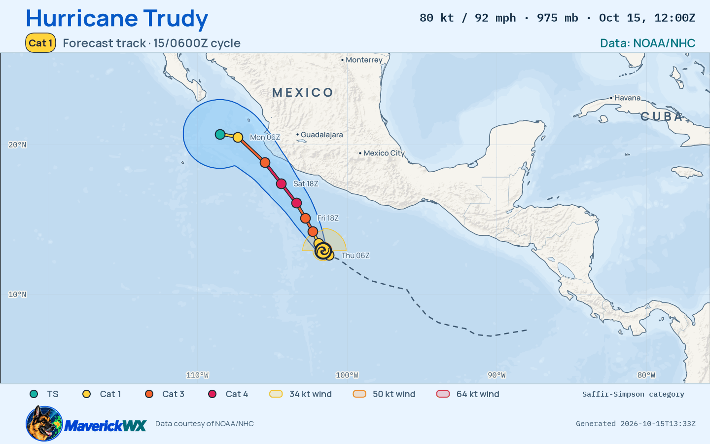
The official forecast track, drawn by this site from NHC’s Best track (). Not an official NHC product. Data: NOAA/NHC. NHC’s own.
80 kt · 92 mph · 975 hPa · NW at 8 kt
Storm Mode · NHC Best track ·
Historical advisory selected · current imagery and impacts are not attached
Observed imagery loads separately from the advisory. The base map is not observed satellite imagery.
The cone describes center uncertainty; impacts can extend outside it.
Forecast positions are estimates, not observations.
Each entry selects one immutable snapshot. Intermediate, special and corrected records are separate identities where retained. Current NWS context is labelled separately. Historical impact manifests are not retained by this index; newer impacts are never attached to an earlier advisory. Same-time corrections replaced in the publisher’s index cannot be selected unless still listed.
Solid: NHC Best track ·
Dashed: NHC Advisory 8 · . Comparison uses each record’s own geometry. A revision is not a landfall or impact prediction.
| Field | Selected issuance | Comparison issuance | Change |
|---|---|---|---|
| Maximum sustained wind | 80 kt · 92 mph | 65 kt · 75 mph | +15 kt |
| Minimum pressure | 975 hPa | 989 hPa | -14 hPa |
| Center position | 12.9°N, 101.6°W | 12.9°N, 101.6°W | Different observation times; not a forecast shift |
| Valid time | Selected position / wind | Previous position / wind | Wind revision |
|---|---|---|---|
| 12.6°N, 101.2°W 65 kt · 75 mph | 12.6°N, 101.2°W 65 kt · 75 mph | 0 kt | |
| 12.9°N, 101.6°W 65 kt · 75 mph | 12.9°N, 101.6°W 65 kt · 75 mph | 0 kt | |
| 13.4°N, 101.9°W 80 kt · 92 mph | 13.4°N, 101.9°W 80 kt · 92 mph | 0 kt | |
| 14.2°N, 102.3°W 100 kt · 115 mph | 14.2°N, 102.3°W 100 kt · 115 mph | 0 kt | |
| 15.1°N, 102.8°W 110 kt · 127 mph | 15.1°N, 102.8°W 110 kt · 127 mph | 0 kt | |
| 16.1°N, 103.4°W 115 kt · 132 mph | 16.1°N, 103.4°W 115 kt · 132 mph | 0 kt | |
| 17.4°N, 104.4°W 115 kt · 132 mph | 17.4°N, 104.4°W 115 kt · 132 mph | 0 kt | |
| 18.8°N, 105.5°W 105 kt · 121 mph | 18.8°N, 105.5°W 105 kt · 121 mph | 0 kt | |
| 20.5°N, 107.3°W 75 kt · 86 mph | 20.5°N, 107.3°W 75 kt · 86 mph | 0 kt | |
| 20.7°N, 108.5°W 60 kt · 69 mph | 20.7°N, 108.5°W 60 kt · 69 mph | 0 kt |
None: no U.S. state or territory is under NHC’s coastal watches or warnings or inside the cone, Best track. Current geographical context; these alerts are not attributed to the cyclone and are not part of the historical advisory.
No U.S. state or territory is under NHC’s coastal watches or warnings or inside the cone. The storm’s own panels are shown, and no NWS alert is listed.
NHC Best track · advisory · forecast cycle . Forecast positions are future estimates, not observed imagery. Classification is shown only where published.
| Valid time / lead | Position | Classification | Sustained wind |
|---|---|---|---|
+0 h from forecast cycle | 12.6°N, 101.2°W | hurricane | 65 kt · 75 mph |
+3 h from forecast cycle | 12.9°N, 101.6°W | hurricane | 65 kt · 75 mph |
+12 h from forecast cycle | 13.4°N, 101.9°W | hurricane | 80 kt · 92 mph |
+24 h from forecast cycle | 14.2°N, 102.3°W | hurricane | 100 kt · 115 mph |
+36 h from forecast cycle | 15.1°N, 102.8°W | hurricane | 110 kt · 127 mph |
+48 h from forecast cycle | 16.1°N, 103.4°W | hurricane | 115 kt · 132 mph |
+60 h from forecast cycle | 17.4°N, 104.4°W | hurricane | 115 kt · 132 mph |
+72 h from forecast cycle | 18.8°N, 105.5°W | hurricane | 105 kt · 121 mph |
+96 h from forecast cycle | 20.5°N, 107.3°W | hurricane | 75 kt · 86 mph |
+120 h from forecast cycle | 20.7°N, 108.5°W | tropical storm | 60 kt · 69 mph |
The storm’s area, by its warning centre’s products: everything listed is in force in this area, never “from this storm”.
The official forecast track, drawn by this site from NHC’s Best track (). Not an official NHC product. Data: NOAA/NHC. NHC’s own.
NHC’s wind speed probabilities are not reported for this advisory.
The advisory’s watches and warnings are not reported.
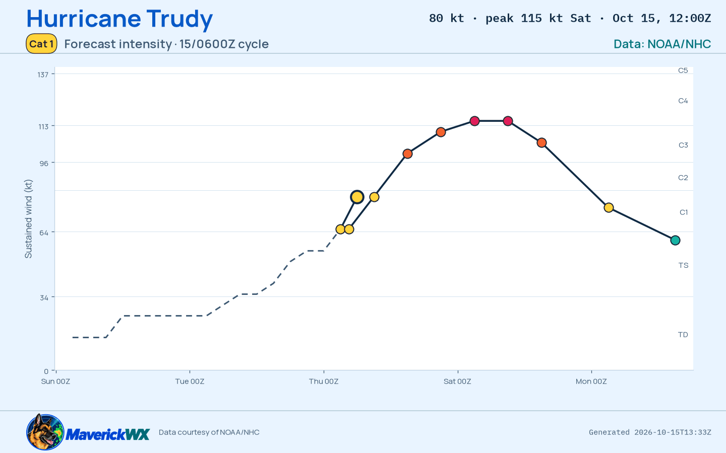
The official intensity forecast, drawn by this site from NHC’s Best track (). Not an official NHC product. Data: NOAA/NHC. NHC’s own.
The storm’s page shows it on the satellite, loaded by your browser.
Imagery from NASA GIBS: NOAA GOES and JMA Himawari.
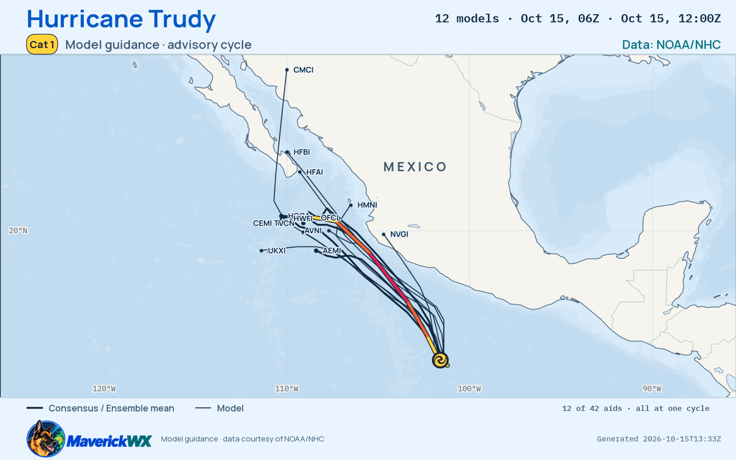
The models’ tracks, which are not a forecast, drawn by this site from NHC’s Best track (). Not an official NHC product. Data: NOAA/NHC. NHC’s own.
NOAA’s radar for the area, loaded by your browser as on the Radar page.
Live tiles; the radar keeps no last-good copy.
NHC best track, as published checked
Radar live tiles, no last-good copy
Not an official warning service. Warnings and watches are the National Weather Service’s, outlooks and reports the Storm Prediction Center’s and the Weather Prediction Center’s (Data: NOAA/NWS, NOAA/SPC, NOAA/WPC). When a warning is issued for you, act on it, and use weather.gov or a NOAA Weather Radio for where you are.