

Forecast track

The official forecast track, drawn by this site from JTWC’s Warning 26 (). Not an official JTWC product. Data: JTWC. JTWC’s own.
Current advisory context · 160 kt · 184 mph · 895 hPa · WNW at 15 kt
Storm Mode · JTWC Warning 26 ·
Latest published advisory
Observed imagery loads separately from the advisory. The base map is not observed satellite imagery.
JTWC does not publish an NHC cone.
Recorded weather · gaps are marked. Coverage begins with recording activation.
Live sources keep independent clocks.
Rolling target: 24 hours; cells: six hours. Radar: NOAA MRMS national overview, 8-minute tolerance. Satellite: original GOES GeoColor day/night picture, hourly sampling, 75-minute tolerance. No interpolation or latest-image fallback. Warning and source checks retain their own clocks. “Recorded by” is collector acquisition evidence, not exact browser publication history.
Current GLM density, velocity and specialist layers are hidden during replay. Snow uses retained footprint metadata with unverified pixel time. Forecast uses one pinned issuance/run and exact valid time.
No observed replay frame displayed.
Open the complete replay reader (works without scripting or WebGL)Choose Forecast for a pinned issuance and valid time.
Current cached context, independently dated. Regional products keep their published footprint; they are not clipped or attributed to one storm. This section remains separate from the historical replay cursor and official cyclone forecast. Use Forecast to pin a retained model package.
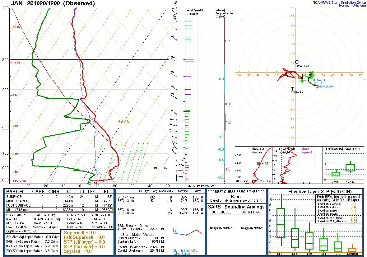
A balloon launched about an hour before the time named, measuring as it rose and drifted with the wind: the atmosphere above one place, at one time. Model soundings, which are forecasts, are not shown here.
| Pressure | Height | Temperature | Dew point | Wind |
|---|---|---|---|---|
| 1013 mb | 91 m | 6.6 | 5.5 | calm |
| 1003 mb | 172 m | 13.8 | 4.8 | — |
| 1000 mb | 197 m | 14.4 | 4.4 | 100° 12 kt |
| 987 mb | 305 m | 16.3 | 3.6 | 110° 14 kt |
| 952 mb | 610 m | 14.4 | 4.5 | 095° 7 kt |
| 932 mb | 793 m | 13.2 | 5.2 | — |
| 925 mb | 856 m | 12.8 | 4.8 | 005° 6 kt |
| 886 mb | 1217 m | 11.8 | -3.2 | — |
| 873 mb | 1341 m | 12.2 | -5.8 | — |
| 861 mb | 1457 m | 13.4 | -11.6 | — |
| 850 mb | 1565 m | 13.0 | -13.0 | 065° 21 kt |
| 835 mb | 1714 m | 14.0 | -29.0 | — |
| 825 mb | 1816 m | 14.8 | -34.2 | — |
| 807 mb | 2002 m | 14.4 | -34.6 | — |
| 794 mb | 2134 m | 13.8 | -35.2 | 085° 9 kt |
| 766 mb | 2438 m | 12.4 | -36.6 | 085° 5 kt |
| 739 mb | 2743 m | 11.4 | -36.9 | 140° 2 kt |
| 712 mb | 3048 m | 9.6 | -37.8 | 315° 10 kt |
| 700 mb | 3188 m | 8.8 | -38.2 | 310° 9 kt |
| 683 mb | 3391 m | 7.6 | -37.4 | — |
| 661 mb | 3658 m | 5.3 | -35.5 | 325° 14 kt |
| 641 mb | 3908 m | 3.2 | -33.8 | — |
| 613 mb | 4267 m | 1.5 | -35.8 | 295° 8 kt |
| 590 mb | 4572 m | 0.1 | -37.5 | 285° 11 kt |
| 568 mb | 4877 m | -1.3 | -39.3 | 290° 9 kt |
| 547 mb | 5182 m | -3.5 | -32.8 | 290° 19 kt |
| 526 mb | 5486 m | -6.0 | -25.4 | 265° 19 kt |
| 513 mb | 5681 m | -7.7 | -20.7 | — |
| 500 mb | 5880 m | -9.5 | -21.5 | 270° 18 kt |
| 486 mb | 6096 m | -11.6 | -22.7 | 280° 16 kt |
| 473 mb | 6306 m | -13.3 | -23.3 | — |
| 454 mb | 6616 m | -16.5 | -19.0 | — |
| 442 mb | 6817 m | -17.5 | -23.5 | — |
| 431 mb | 7006 m | -17.7 | -32.7 | — |
| 414 mb | 7306 m | -19.5 | -33.5 | — |
| 400 mb | 7560 m | -21.9 | -32.9 | 305° 24 kt |
| 374 mb | 8049 m | -26.7 | -32.7 | — |
| 342 mb | 8686 m | -32.7 | -33.8 | — |
| 322 mb | 9112 m | -31.3 | -59.3 | — |
| 300 mb | 9610 m | -34.1 | -61.1 | 305° 28 kt |
| 278 mb | 10141 m | -37.7 | -61.7 | — |
| 251 mb | 10843 m | -41.1 | -67.1 | — |
| 250 mb | 10870 m | -40.9 | -67.9 | 300° 31 kt |
| 232 mb | 11374 m | -43.5 | -68.5 | — |
| 214 mb | 11914 m | -45.7 | -74.7 | — |
| 200 mb | 12360 m | -49.1 | -76.1 | 300° 41 kt |
| 184 mb | 12901 m | -53.7 | -78.7 | — |
| 165 mb | 13593 m | -57.9 | -79.9 | — |
| 154 mb | 14021 m | -59.9 | -81.5 | 305° 30 kt |
| 150 mb | 14190 m | -60.9 | -81.9 | 300° 32 kt |
| 136 mb | 14793 m | -63.9 | -83.9 | — |
| 124 mb | 15353 m | -68.1 | -85.1 | — |
| 111 mb | 16014 m | -69.9 | -85.9 | — |
| 100 mb | 16630 m | -71.7 | -86.7 | 335° 29 kt |
SPC observed soundings checked · Data: NOAA/SPC
None: JTWC’s forecast track passes within 300 nm of no U.S. territory with NWS zones, Warning 26. Current geographical context; these alerts are not attributed to the cyclone.
No U.S. territory is in this storm’s area: JTWC’s track passes within 300 nm of none. Its own panels are shown, and no NWS alert is listed.
JTWC Warning 26 · advisory · forecast cycle . Forecast positions are future estimates, not observed imagery. Classification is shown only where published.
| Valid time / lead | Position | Classification | Sustained wind |
|---|---|---|---|
+12 h from forecast cycle | 18.6°N, 129.1°E | super typhoon | 155 kt · 178 mph |
+24 h from forecast cycle | 19.8°N, 127.2°E | super typhoon | 150 kt · 173 mph |
+36 h from forecast cycle | 20.9°N, 125.8°E | super typhoon | 135 kt · 155 mph |
+48 h from forecast cycle | 22.2°N, 124.8°E | typhoon | 125 kt · 144 mph |
+60 h from forecast cycle | 24.0°N, 123.9°E | typhoon | 115 kt · 132 mph |
+72 h from forecast cycle | 25.8°N, 123.6°E | typhoon | 95 kt · 109 mph |
+96 h from forecast cycle | 30.4°N, 126.2°E | typhoon | 65 kt · 75 mph |
+120 h from forecast cycle | 33.3°N, 131.2°E | tropical storm | 50 kt · 58 mph |
Each entry selects one immutable snapshot. Intermediate, special and corrected records are separate identities where retained. Current NWS context is labelled separately. Historical impact manifests are not retained by this index; newer impacts are never attached to an earlier advisory. Same-time corrections replaced in the publisher’s index cannot be selected unless still listed.
The storm’s area, by its warning centre’s products: everything listed is in force in this area, never “from this storm”.
The official forecast track, drawn by this site from JTWC’s Warning 26 (). Not an official JTWC product. Data: JTWC. JTWC’s own.

The official intensity forecast, drawn by this site from JTWC’s Warning 26 (). Not an official JTWC product. Data: JTWC. JTWC’s own.
The storm’s page shows it on NASA GIBS (NOAA GOES, JMA Himawari)’s imagery, loaded by your browser. Himawari at 9° from the storm's meridian.
Imagery from NASA GIBS: NOAA GOES and JMA Himawari.

The models’ tracks, which are not a forecast, drawn by this site from JTWC’s Warning 26 (). Not an official JTWC product. Data: JTWC. JTWC’s own.
NOAA’s radar for the area, loaded by your browser as on the Radar page.
Live tiles; the radar keeps no last-good copy.
JTWC warning, as published checked
Radar live tiles, no last-good copy
Not an official warning service. Warnings and watches are the National Weather Service’s, outlooks and reports the Storm Prediction Center’s and the Weather Prediction Center’s (Data: NOAA/NWS, NOAA/SPC, NOAA/WPC). When a warning is issued for you, act on it, and use weather.gov or a NOAA Weather Radio for where you are.