

Forecast track
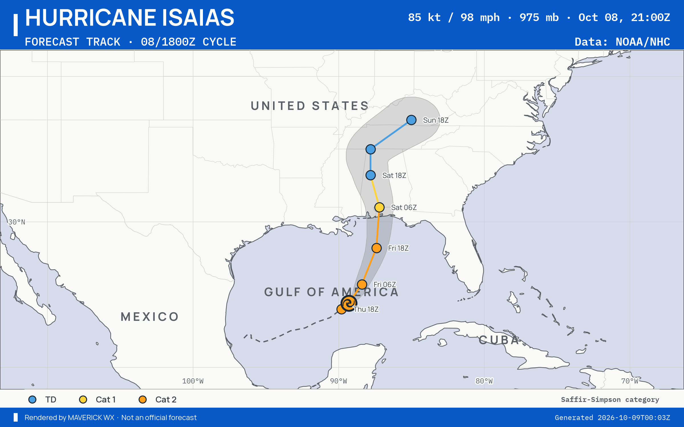
The official forecast track, drawn by this site from NHC’s Advisory 9 (). Not an official NHC product. Data: NOAA/NHC. NHC’s own.
Current advisory context · 85 kt · 98 mph · 975 hPa · NE at 10 kt
Storm Mode · NHC Advisory 9 ·
Historical advisory selected · current imagery and impacts are not attached
Replay uses retained source bytes. Recording begins with activation; missing history is not clear weather.
Live sources keep independent clocks.
Rolling target: 24 hours; cells: six hours. Radar: NOAA MRMS national overview, 8-minute tolerance. Satellite: original GOES GeoColor day/night picture, hourly sampling, 75-minute tolerance. No interpolation or latest-image fallback. Warning and source checks retain their own clocks. “Recorded by” is collector acquisition evidence, not exact browser publication history.
Current GLM density, velocity and specialist layers are hidden during replay. Snow uses retained footprint metadata with unverified pixel time. Forecast uses one pinned issuance/run and exact valid time.
No observed replay frame displayed.
Open the complete replay reader (works without scripting or WebGL)Observed imagery loads separately from the advisory. The base map is not observed satellite imagery.
The cone describes center uncertainty; impacts can extend outside it.
Use Forecast above to pin an official issuance and valid point. The forecast table and advisory history remain available below.
Each entry selects one immutable snapshot. Intermediate, special and corrected records are separate identities where retained. Current NWS context is labelled separately. Historical impact manifests are not retained by this index; newer impacts are never attached to an earlier advisory. Same-time corrections replaced in the publisher’s index cannot be selected unless still listed.
Solid: NHC Advisory 9 ·
Dashed: NHC Best track · . Comparison uses each record’s own geometry. A revision is not a landfall or impact prediction.
| Field | Selected issuance | Comparison issuance | Change |
|---|---|---|---|
| Maximum sustained wind | 85 kt · 98 mph | 75 kt · 86 mph | +10 kt |
| Minimum pressure | 975 hPa | 977 hPa | -2 hPa |
| Center position | 24.4°N, 89.3°W | 24.0°N, 89.8°W | Different observation times; not a forecast shift |
Forecast comparison unavailable: these records have no matching forecast valid times. No interpolation or six-hour step is assumed.
States under NHC’s coastal watches and warnings and inside the cone, Advisory 9: Alabama, Florida, Georgia, Indiana, Kentucky, Mississippi, Tennessee and Virginia. Current geographical context; these alerts are not attributed to the cyclone and are not part of the historical advisory.
Most urgent first, by the Briefing’s ranking. Checked .
Lake and Volusia counties, FL
Flood Warning issued October 17 at 9:04AM EDT by NWS Melbourne FL
Issued · ends
Official Flood Warning bulletinSarasota County, FL
Flood Warning issued October 17 at 9:02AM EDT until October 18 at 8:00AM EDT by NWS Tampa Bay Ruskin FL
Issued · ends
Official Flood Warning bulletinBrantley County, GA
Flood Warning issued October 17 at 9:20AM EDT by NWS Jacksonville FL
Issued · ends
Official Flood Warning bulletinAshley; Chicot; Morehouse; West Carroll; East Carroll; Richland; Madison; Franklin; Catahoula; Tensas; Concordia; Bolivar; Sunflower; Leflore; Grenada; Carroll; Montgomery; Webster; Clay; Lowndes; Choctaw; Oktibbeha; Washington; Humphreys; Holmes; Attala; Winston; Noxubee; Issaquena; Sharkey; Yazoo; Madison; Leake; Neshoba; Kemper; Warren; Hinds; Rankin; Scott; Newton; Lauderdale; Claiborne; Copiah; Simpson; Smith; Jasper; Clarke; Jefferson; Adams; Franklin; Lincoln; Lawrence; Jefferson Davis; Covington; Jones; Marion; Lamar; Forrest
Red Flag Warning issued October 17 at 5:35AM CDT until October 17 at 7:00PM CDT by NWS Jackson MS
Issued · ends
Official Red Flag Warning bulletinWayne; Perry; Greene; Stone; George
Red Flag Warning issued October 17 at 7:32AM CDT until October 17 at 7:00PM CDT by NWS Mobile AL
Issued · ends
Official Red Flag Warning bulletinPointe Coupee; West Feliciana; East Feliciana; St. Helena; Washington; Iberville; West Baton Rouge; East Baton Rouge; Assumption; St. James; Northern Tangipahoa; Southeast St. Tammany; Northern St. Tammany; Southwestern St. Tammany; Central Tangipahoa; Lower Tangipahoa; Northern Livingston; Southern Livingston; Western Ascension; Eastern Ascension; Wilkinson; Amite; Pike; Walthall; Pearl River; Hancock; Harrison; Jackson
Red Flag Warning issued October 17 at 1:23PM CDT until October 17 at 8:00PM CDT by NWS New Orleans LA
Issued · ends
Official Red Flag Warning bulletinInland Worcester
Coastal Flood Watch issued October 17 at 11:49AM EDT until October 20 at 9:00AM EDT by NWS Wakefield VA
Issued · ends
Official Coastal Flood Watch bulletinMaryland Beaches; Accomack; Northampton
Coastal Flood Watch issued October 17 at 11:49AM EDT until October 20 at 9:00AM EDT by NWS Wakefield VA
Issued · ends
Official Coastal Flood Watch bulletinEastern Currituck
Coastal Flood Watch issued October 17 at 11:49AM EDT until October 20 at 9:00AM EDT by NWS Wakefield VA
Issued · ends
Official Coastal Flood Watch bulletinSurry; James City; Newport News; Isle of Wight
Coastal Flood Watch issued October 17 at 11:49AM EDT until October 20 at 9:00AM EDT by NWS Wakefield VA
Issued · ends
Official Coastal Flood Watch bulletinChesapeake; Suffolk; Norfolk; Portsmouth
Coastal Flood Watch issued October 17 at 11:49AM EDT until October 20 at 9:00AM EDT by NWS Wakefield VA
Issued · ends
Official Coastal Flood Watch bulletinVirginia Beach
Coastal Flood Watch issued October 17 at 11:49AM EDT until October 20 at 9:00AM EDT by NWS Wakefield VA
Issued · ends
Official Coastal Flood Watch bulletinNHC Advisory 9 · advisory · forecast cycle . Forecast positions are future estimates, not observed imagery. Classification is shown only where published.
| Valid time / lead | Position | Classification | Sustained wind |
|---|---|---|---|
+0 h from forecast cycle | 24.0°N, 89.8°W | hurricane | 85 kt · 98 mph |
+3 h from forecast cycle | 24.4°N, 89.3°W | hurricane | 85 kt · 98 mph |
+12 h from forecast cycle | 25.7°N, 88.4°W | hurricane | 95 kt · 109 mph |
+24 h from forecast cycle | 28.2°N, 87.4°W | hurricane | 85 kt · 98 mph |
+36 h from forecast cycle | 31.0°N, 87.2°W | hurricane | 65 kt · 75 mph |
+48 h from forecast cycle | 33.2°N, 87.8°W | low | 30 kt · 35 mph |
+60 h from forecast cycle | 35.0°N, 87.8°W | low | 25 kt · 29 mph |
+72 h from forecast cycle | 37.0°N, 85.0°W | low | 20 kt · 23 mph |
The storm’s area, by its warning centre’s products: everything listed is in force in this area, never “from this storm”.
NWS’s polygons as issued, or the zones a zone-issued alert names; SPC’s watches by their counties. Checked . Data: NOAA/NWS, NOAA/SPC.
Nothing has changed since 19:29Z.
The products’ own words and times, and what is no longer in force since the last read. Never written by AI.
The official forecast track, drawn by this site from NHC’s Advisory 9 (). Not an official NHC product. Data: NOAA/NHC. NHC’s own.
NHC’s wind speed probabilities are not reported for this advisory.
The advisory’s watches and warnings are not reported.
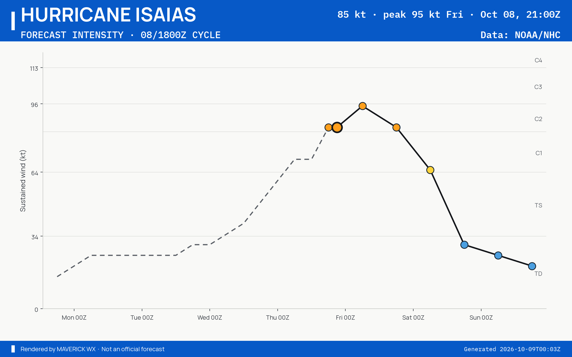
The official intensity forecast, drawn by this site from NHC’s Advisory 9 (). Not an official NHC product. Data: NOAA/NHC. NHC’s own.
The storm’s page shows it on the satellite, loaded by your browser.
Imagery from NASA GIBS: NOAA GOES and JMA Himawari.
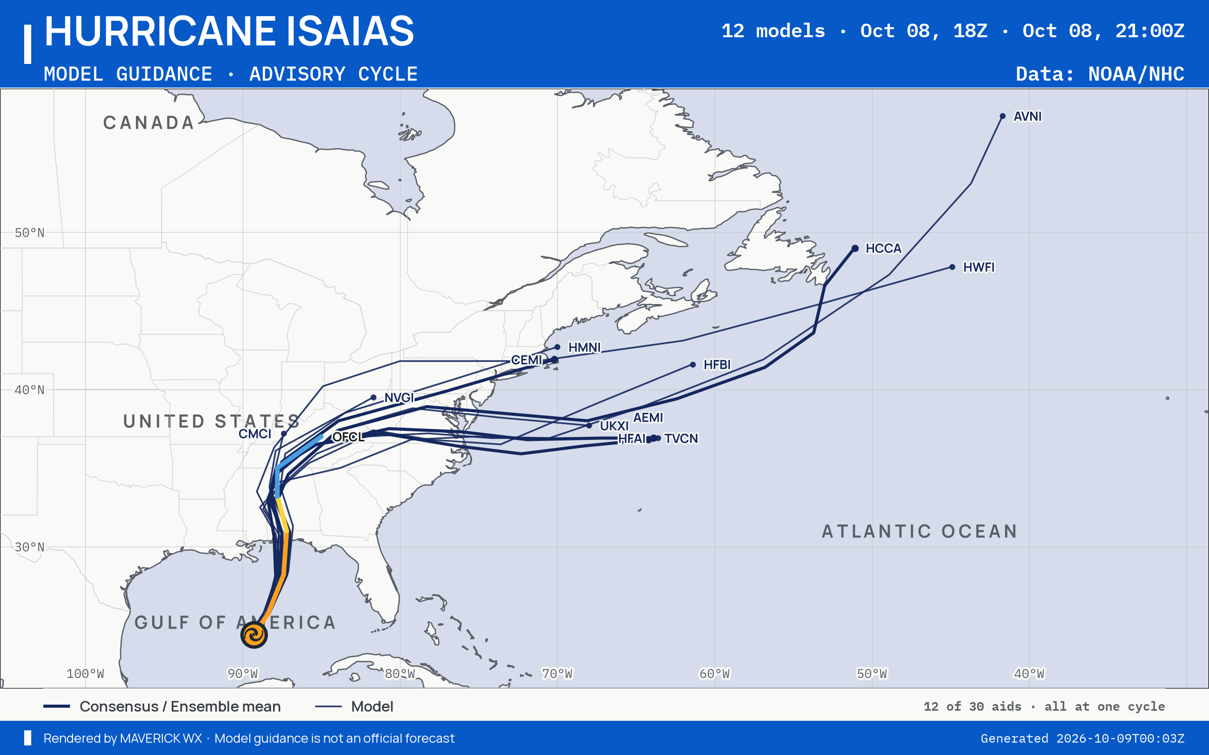
The models’ tracks, which are not a forecast, drawn by this site from NHC’s Advisory 9 (). Not an official NHC product. Data: NOAA/NHC. NHC’s own.
WPC’s excessive rainfall outlook, to , issued : a chance of flash flooding, in four categories. Data: NOAA/WPC.
1 major · 8 moderate · 21 minor · 31 at action stage
NWS’s gauges at flood stage or above in the area, worst first, each with its forecast hydrograph on Rain & rivers. Data: NOAA/NWPS.
WPC’s rain forecast and MRMS’s radar estimate of the rain that fell, on the Briefing’s map for the area.
Data: NOAA/WPC, NOAA/NSSL MRMS.
SPC’s Day 1 categorical outlook, valid to , issued . SPC’s categories, as drawn. Data: NOAA/SPC.
No tornado or severe thunderstorm watch in force in this area.
SPC’s watches, by number, matched by the counties they list. Data: NOAA/SPC.
No mesoscale discussion reaches this area.
SPC’s mesoscale discussions whose outline reaches the area. Data: NOAA/SPC.
SPC’s hourly mesoanalysis, observed soundings and model guidance for the area, on the Analysis tab with its own clocks.
Drawn by the Analysis tab’s own renderer. Data: NOAA/SPC, NOAA/NCEP.
NOAA’s radar for the area, loaded by your browser as on the Radar page.
Live tiles; the radar keeps no last-good copy.
NHC advisory, as published checked
NWS warnings and SPC watches checked
NWS watches and advisories checked
SPC mesoscale discussions checked
SPC Day 1 outlook checked
WPC excessive rainfall checked
NWPS river gauges checked
Radar live tiles, no last-good copy
Not an official warning service. Warnings and watches are the National Weather Service’s, outlooks and reports the Storm Prediction Center’s and the Weather Prediction Center’s (Data: NOAA/NWS, NOAA/SPC, NOAA/WPC). When a warning is issued for you, act on it, and use weather.gov or a NOAA Weather Radio for where you are.